


Единая платформа
для карт и геоданных
Программы и сервисы для ведения ГИС, управления картами и пространственными данными.
- В облаке и на ваших серверах
- В реестре отечественного ПО
- Проекты любого масштаба


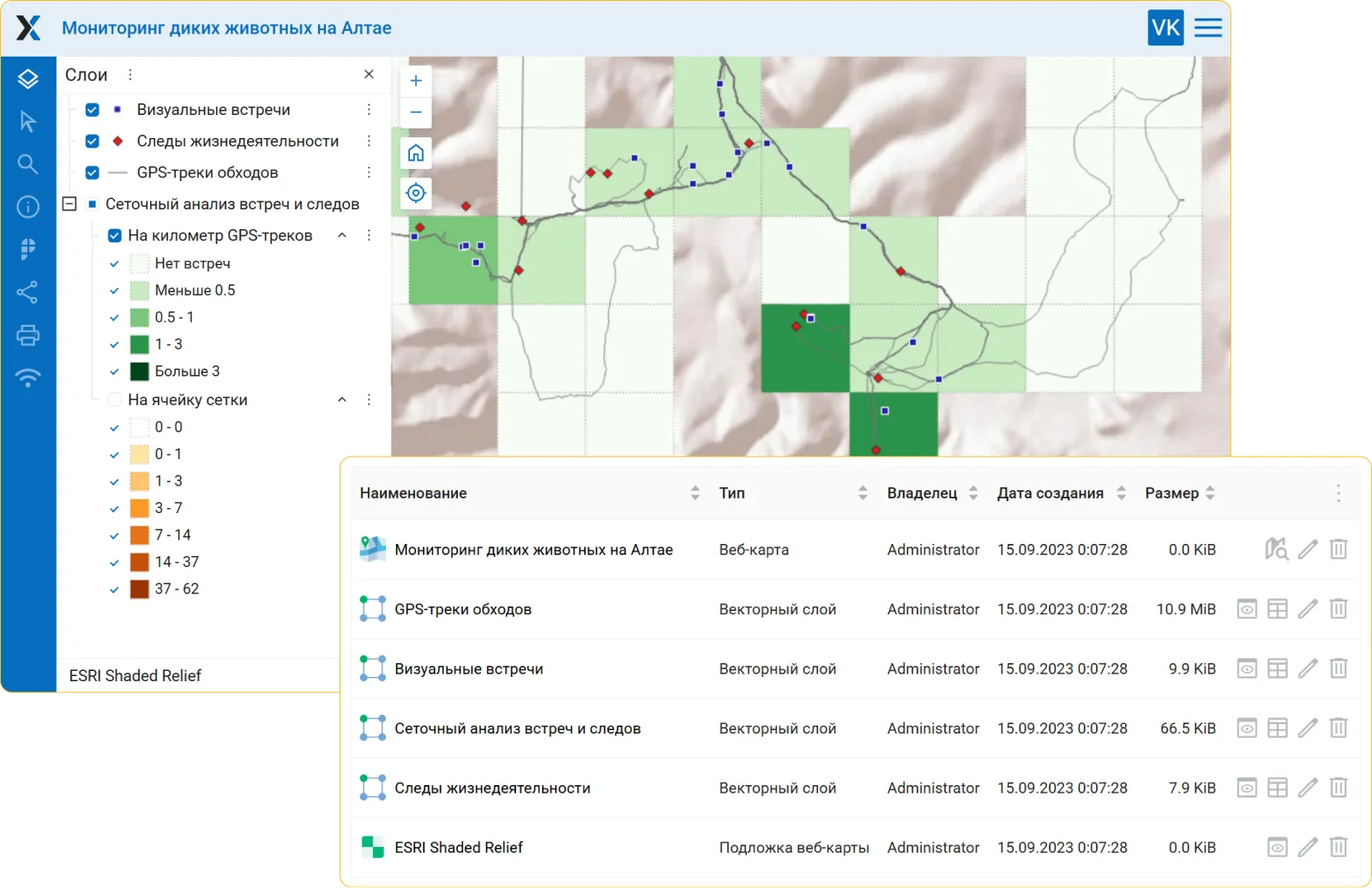
Управляйте пространственными данными
- Единое пространство для ваших геоданных
- Редактирование и настройка данных и карт
- Гибкая настройка доступа
- Мощный API для интеграции с другими системами
- Простое развёртывание в облаке или на ваших серверах


Бесшовная интеграция с QGIS
- Публикация проектов QGIS в виде веб‑карт в один клик
- Автоматическая синхронизация данных
- Полная поддержка стилей QGIS
- Совместное редактирование и работа над проектами
- Своя сборка для организаций с повышенными требованиями к безопасности
Базовые карты на вашем сервере
- Свои базовые карты
- Идеально для внутренней сети организации
- Используйте открытые или собственные данные
- Полный контроль над охватом, стилями и доступом


Готовые наборы геоданных
- Тематические векторные и растровые данные
- Базовые карты, рельеф, здания, дороги и многое другое
- Готовый к работе проект за считанные минуты


GPS-мониторинг техники и персонала
- Накопление и анализ информации о перемещениях
- Автоматическая синхронизация с базой данных
- Интеграция с интерактивными картами
Создавайте свои приложения
- Эффективные инструменты для самостоятельной разработки
- Удобные библиотеки для фронтенд-разработчиков
- Полный доступ через API
- Автоматизация любых задач


Наши клиенты
Нам доверяют ведущие компании и государственные организации России.


Не нашли нужное решение?
Мы разрабатываем инструменты специально под нужды клиента. Свяжитесь с нами, и мы предложим решение.
-
Под ваши требованияУчитываем особенности ваших процессов.
-
Экспертная поддержкаСпециалисты с большим опытом в ГИС помогут на каждом этапе.
-
Любая инфраструктураОблако, ваши сервера, гибридные решения.
Опишите ваши задачи


