New version of QuickMapServices – QGIS plugin for painless adding of the basemaps as layers is out (more about the plugin).
Here is what’s new:
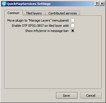
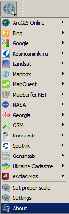
1. Settings windows
QuickMapServices has now proper place to make plugin-wide settings. Right now you can make the following settings:
- Move plugin icon to “Manage Layers” toolbar (by default it is located on “Web” toolbar which is often lost)
- Enable OTF EPSG:3857 on adding tile layers (if checked, the project will get on-the-fly reprojection automatically turned on to EPSG: 3857 Pseudo Mercator if tile layer is added).
- Show information in the messages panel (by default messages are shown in pop-up panel which is not always convenient)
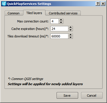
You can also set up few things for tiles provider, such as:
- Maximum number of connections
- Cache expiration interval (hours)
- Tile loading timeout
 |
 |
2. Contibuted services pack
If you have your own favorite basemaps and tired of moving them around from a machine to machine and would like them to be included in QuickMapServices – now there is a easy way to do it. We set up a special repository for such descriptions which will act like a clearinghouse before they ‘graduate’ to core package.
https://github.com/nextgis/quickmapservices_contrib
Just send us a pull request against this repository and we will most likely accept it. It will them become avalailable for everybody. The user will need to go to Settings, Contributed services tab and hit “Get contribute pack”.
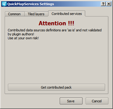 Important: we are NOT validating contributed services, they are provided and proof-of-concept for testing only.
We can promote a service description from contributed to base to be available right away, but such service should not raise any licensing uncertainties and should be properly and explicitly described. Here is how ‘base’ vs ‘contributed’ looks currently:
3. Other changes
- You can now set yOriginTop parameter for TMS layers – for cases when Y coordinates are increasing from South to North (example for Ukraine Cadaster)
- You can use quadkeys in services url (example for Bing).
- Services settings are now separate from the plugin and will not get removed after removal of the plugin or an update.
Hi,
I have this tracback when I try to get the “contributed pack”.
Do imagine why?
Traceback (most recent call last):
File “C:/Users/pedro.ferro/.qgis2/python/plugins\quick_map_services\settings_dialog.py”, line 86, in get_contrib
error_message = self.tr(‘Error on getting contrib pack: %s %s’) % (sys.exc_type, sys.exc_value)
UnicodeDecodeError: ‘ascii’ codec can’t decode byte 0xe7 in position 50: ordinal not in range(128)
Versão do Python:
2.7.4 (default, Apr 6 2013, 19:54:46) [MSC v.1500 32 bit (Intel)]
Versão do QGIS:
2.8.1-Wien Wien, exported
Caminho para o Python: [‘C:/Users/pedro.ferro/.qgis2/python/plugins\\processing’, ‘C:\\Users\\pedro.ferro\\.qgis2\\python\\plugins\\opengeo\\ext-libs\\requests-2.0.1-py2.7.egg’, ‘C:\\Users\\pedro.ferro\\.qgis2\\python\\plugins\\opengeo\\ext-libs\\python_dateutil-2.2-py2.7.egg’, ‘C:\\Users\\pedro.ferro\\.qgis2\\python\\plugins\\opengeo\\ext-libs\\six-1.9.0-py2.7.egg’, ‘C:\\Users\\pedro.ferro\\.qgis2\\python\\plugins\\opengeo\\ext-libs\\lxml-3.3.5-py2.7-win32.egg’, ‘C:\\Users\\pedro.ferro\\.qgis2\\python\\plugins\\opengeo\\ext-libs\\gsimporter-0.2-py2.7.egg’, ‘C:\\Users\\pedro.ferro\\.qgis2\\python\\plugins\\opengeo\\ext-libs\\httplib2-0.9-py2.7.egg’, ‘C:/OSGeo4W/apps/qgis/./python’, u’C:/Users/pedro.ferro/.qgis2/python’, u’C:/Users/pedro.ferro/.qgis2/python/plugins’, ‘C:/OSGeo4W/apps/qgis/./python/plugins’, ‘C:\\OSGeo4W\\bin\\python27.zip’, ‘C:\\OSGeo4W\\apps\\Python27\\DLLs’, ‘C:\\OSGeo4W\\apps\\Python27\\lib’, ‘C:\\OSGeo4W\\apps\\Python27\\lib\\plat-win’, ‘C:\\OSGeo4W\\apps\\Python27\\lib\\lib-tk’, ‘C:\\OSGeo4W\\bin’, ‘C:\\OSGeo4W\\apps\\Python27’, ‘C:\\OSGeo4W\\apps\\Python27\\lib\\site-packages’, ‘C:\\OSGeo4W\\apps\\Python27\\lib\\site-packages\\PIL’, ‘C:\\OSGeo4W\\apps\\Python27\\lib\\site-packages\\jinja2-2.7.2-py2.7.egg’, ‘C:\\OSGeo4W\\apps\\Python27\\lib\\site-packages\\markupsafe-0.23-py2.7-win32.egg’, ‘C:\\OSGeo4W\\apps\\Python27\\lib\\site-packages\\python_dateutil-2.2-py2.7.egg’, ‘C:\\OSGeo4W\\apps\\Python27\\lib\\site-packages\\pytz-2014.2-py2.7.egg’, ‘C:\\OSGeo4W\\apps\\Python27\\lib\\site-packages\\win32’, ‘C:\\OSGeo4W\\apps\\Python27\\lib\\site-packages\\win32\\lib’, ‘C:\\OSGeo4W\\apps\\Python27\\lib\\site-packages\\Pythonwin’, ‘C:\\OSGeo4W\\apps\\Python27\\lib\\site-packages\\Shapely-1.2.18-py2.7-win32.egg’, ‘C:\\OSGeo4W\\apps\\Python27\\lib\\site-packages\\six-1.6.1-py2.7.egg’, ‘C:\\OSGeo4W\\apps\\Python27\\lib\\site-packages\\wx-2.8-msw-unicode’, u’C:/Users/pedro.ferro/.qgis2//python’, ‘C:\\Users\\pedro.ferro\\.qgis2\\python\\plugins\\mmqgis/forms’, ‘C:\\Users\\pedro.ferro\\.qgis2\\python\\plugins\\opengeo\\ext-libs’, ‘C:\\Users\\pedro.ferro\\.qgis2\\python\\plugins\\QuickMultiAttributeEdit/forms’, ‘.’, ‘C:\\OSGeo4W\\apps\\qgis\\python\\plugins\\fTools\\tools’]
Hi Pedro, can you please create an issue here? https://github.com/nextgis/quickmapservices/issues
If you don’t have an account I’ll be happy to create an issue for you.
Done
https://github.com/nextgis/quickmapservices/issues/32